
Hawaii Sailing
A Paradise for ocean sailors
Sailors love the variety of sailing conditions they experience sailing around the Hawaiian Islands making Hawaii the perfect venue to practice interisland passage making or receive sailing instruction focused on bluewater skills.
Hawaiian sailors routinely sail conditions that are tropical by nature — yet, the weather in Hawaii is often variable — influenced by cool air descending from high volcanos, or changed by the occasional weather front.
When you also consider the potential for big surf that Hawaii is renown for, it’s fair to say Hawaiian sailors have access to the ingredients that create a fun oceanographic world — all of which provide the full-spectrum of natural elements you need to experience sailing to the fullest extent possible — meaning, you can sail idyllic conditions one day, and venture out into extreme conditions the next to challenge yourself.
Hawaiian Islands Make Their Own Weather
Let’s look specifically at Hawaii Island for a moment — the island is so “large” that locals call it Big Island which refers to something greater than just its square area — Hawaii Island is BIG for many reasons!
Big Island’s topography rises sharply from sea level to 13,796’ where the summit of a dormant volcano called Mauna Kea is only 15 miles from the coast — impressive indeed — but, Big Island is also home to the largest mountain in the world named Mauna Loa when measured from sea floor to summit!
The island of Hawaii is so geographically significant that 10 of Earth’s 14 Climate Zones are found there: Tundra to Desert — with contrasting differences of rainfall on opposite sides of the island. In fact, the city of Kailua-Kona (Big Island’s leeward coast) is “dry” and reports 2” of rain monthly, while it’s windward city Hilo reports 14” of rainfall / month.
Hawaii Sailing offers equal parts — relaxation, challenge, and skill development.
Sailing in the Hawaiian Islands
Easterly Trade Winds of 12-18 knots generally flow across the Hawaiian Islands. Occasionally northerly winds impact the islands too when cold fronts descend from the northwest. Hawaii sailing conditions offer great variety — winds between 5-35 knots are commonly experienced during a week of Hawaii sailing depending on the regional barometric wind field, and whether we’re sailing in the lee of a volcanic mountain, or experiencing accelerated winds as we sail interisland passages across channels where Trades Winds are propelled between cold mountain-air and warm coasts.
Sailing in the lee of high volcanoes offers protection from easterly Trade Winds — thus, the west coasts of the Hawaiian Islands consistently provide incredibly fantastic sailing conditions!
Interisland Hawaiian channels, like the Alenuihaha Channel between Maui and Hawaii Island, or the Pailolo Channel between Molokai and Maui can produce winds that exceed 35 knots when land/sea temperatures have a relatively high difference and when the barometric pressure-gradient is also steep — sometimes “channel-winds” will blow 15 knots higher than average Trade Winds found elsewhere in the island chain on the same day! Wind conditions around the northern and southern-tips of Hawaiian Islands tend to also “wrap-around” and blow to Gale Force along a leeward coast.
Hawaii sailing conditions can be predicted by aware sailors if they understand the dominant weather phenomena affecting the locale.
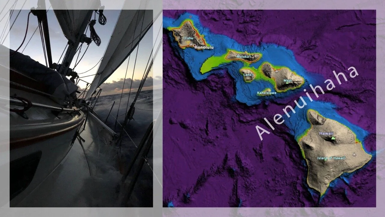
CROSSING THE ALENUIHAHA CHANNEL (STORY): Wind-speeds in the Alenuihaha Channel are routinely understated in forecasts by the National Weather Service—wind-gust measurements can be DOUBLE the forecast.
It’s difficult to get weather-models to produce error-free predictions in Hawaii, despite what Windy Ap, or GFS Model, or whatever "convincing" numerical prediction is trying to sell you. Professional meteorologists trained to interpret models and provide educated opinions often can’t accurately predict Hawaiian winds. In fact, I phoned the NWS in Honolulu and chatted directly with a meteorologist there who told me we'd see 15-18 knots of wind in the Alenuihaha (the day I wrote this story) — instead we encountered sustained wind in the low 40-knot range.
There's an accelerated "wrap around" effect that mariners experience while sailing the Hawaiian Channels—the wind increases significantly at the north and south corners of the islands. The phenomenon is related to a few physical oceanographic features making it hard to model correctly on a broad scale, mostly due to the prevalence of vorticity which Computational Fluid Dynamics still can't get right a lot of the time. There are several meteorological parameters that contribute to the phenomenon we call “wrap around” effect: barometric pressure; insolation; humidity; land/sea temperatures-differences; Troposphere anomalies (ridge/trough); gradient wind-fields, and compounding centripetal forces leading to vortex-wrapping into a localized LOW born above a massive islands like Big Island with two volcanoes over 13,500' tall.
While crossing the Alenuihaha Channel on July 16, 2019, our heavy-weather setup was a triple-reef mainsail, storm jib, and furl-reefed working-Yankee. I re-ran the staysail sheets to a windward secondary winch, and ran the Yankee furling-line to a dedicated winch. I setup the running backstay to the lazy-primary winch. The mainsheet was rigged normal. I pre-made my favorite tuna-salad ... and we headed out from Oneloa Beach on Maui for Kalihi Point on Hawaii Island.
When we got out from behind the wind shadow of Haleakala volcano on Maui (10,000 ft elev.) the breeze picked up to mid 20s. We could see lights ahead with intermittent illumination, confusing, we later figured they weren't from ships at all, but from aircraft, were told later that there's air-cargo service which could've explained what we were seeing.
Then the puffs started coming in. Big puffs — and head seas!
Solstice would rise up and point to the stars in the sky. Low-level cumulus clouds typical of Trade Wind weather blew rapidly overhead against the near full moon. We had to feather in the stuff, and could sail when it got a bit lighter.
SOLSTICE WAS FLYING ... man, she was in the groove in Heavy Weather! I took the helm directly for about 1.5 hours and I became totally conscious of what we were doing. I was having a blast hand-steering the boat! She was going up wind like a freight-train. Occasionally she'd hit a wave and slow-down fast, lost inertia translated into a torquing motion of our bodies. The salt spray was wild — so much salt was caked on my face and eyebrows that my face began to hurt!
It all became SO real when the Moon set an hour before sunrise as we were 20nm west of Upolu Point, Big Island ... It blew, man did blow hard! The wrap around was kicking in. Pitch blackness all around. The rigging was howling! We carefully furled the already partially furled Yankee. The triple-reefed mainsail and storm jib was still too much sail — the fore-reaching heavy weather method produced SO MUCH apparent wind that Solstice's aerodynamic plan was SO AMPED-UP! I thought the additional forces could break the main-halyard, mast-head sheave, or mainsheet tackle; I bled the power and feathered; we opened the sheets and balanced the plan.
We sailed the Alenuihaha Channel
Paul Exner
16 July, 2019
Safe in Kailua-Kona, Hawaii
Coastal air-temperatures around the Hawaiian Islands fluctuate daily as warm sea breezes blow during the day between 75-85º F, and cold land breezes descend from volcanic mountains at night to chill the coast to 58-72º F.
Squally weather is infrequent but occurs year-round due to frontal passages, upper-atmosphere troughs, or when low pressure systems pass near the Hawaiian islands and bring moist-air to the region. Windward coasts feel tropical as humid easterly Trade Winds condense and rain as they ascend windward facing volcanic mountains.
Sailors know Hawaii is renown for epic surf
Ocean swells come to Hawaii from every corner of the Pacific Ocean — from the Tasman to Bering Sea, thousands of miles away!
During winter months, Hawaii’s coastlines will experience ground swells, meaning that wave periods of 12-16 seconds roll across the ocean waters of Hawaii. Because the wave periods are relatively far apart and the coastal waters of Hawaii’s shores are relatively deep, Hawaiian sailors experience gentle rolling swells at sea, and can anchor safely outside the surf zone and find respite in a beautiful and remote anchorage most of the time.

Winter ground swells are barely recognizable in deep water but peak-up near shore in 30 feet of water-depth. When strong winds blow, wind-waves of 6-8 feet are produced offshore and along Hawaiian coasts where the shore is directly exposed to the wind. Summer swell conditions are relatively flat unless Hurricane winds produce storm waves in the Central Pacific Ocean.
Hawaii Sailing — a paradise experience for sailors seeking to challenge themselves and enjoy remote anchorages.